
Background
The Army requires a Multi-Domain Operations (MDO) ready force that can seamlessly transition from one domain to the other, such as those during maritime littoral operations. The WSSOF is a tool that can improve transition efficiency by enabling the warfighter to apriori investigate littoral zone operations in a manner that exercises all possibilities of environmental conditions such as wave heights, winds etc. in a manner that is safe and effective.
Objectives
This collaborative effort between the USC’s Institute for Creative Technologies, the Viterbi School of Engineering, and ERDC’s Coastal and Hydraulics Laboratory (CHL), will foster a leap forward in hyper-realistic ship motion using improvements in numerical simulations of vessel motion, Information Technology (IT), as well as computational speeds to enable the physics-based and real-time simulation of these interactions. Contemporary ship simulations are large, bulky, and stationary with minimal portability.
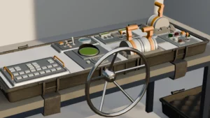
To mitigate these limitations a network enabled ship simulator equipped with Virtual and Mixed-Reality technology coupled with high fidelity numerical modeling can provide a means to meet these operational needs and enhance ship survivability in operational deployments.
Results
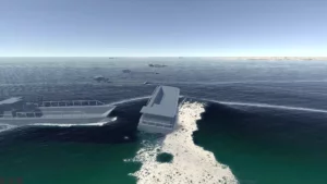
The team made significant progress in year 1 on the research and development of the WSSOF application. The interdisciplinary team successfully developed a VR-enabled system that allows a single user to pilot a vessel within a geo-specific coastal environment. This was accomplished by combining littoral zone wave physics models with a water rendering system in a 3D game engine. This combined system results in visually appealing, dynamic, realistic, and real-time near shore waves within the simulation environment.
Additionally, the team created an enhanced terrain loading pipeline to accurately visualize geo-specific environments like Miami Beach and Duck, North Carolina. This pipeline leverages DEM data from various sources and combines it with bathymetry data.
Next Steps
The team is currently seeking sponsorship to support continued research and development of the WSSOF application.
Future development plans for the project will enhance the application with the integration of a modular user-interface, additional terrain and vessel models, and network protocols for multi-user simulations, promising safer, cost-effective, and immersive preparation for maritime operations and training.
Published academic research papers are available here. For more information Contact Us