
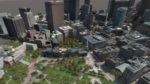

The objective of the 3D Geospatial Research project is to provide a set of 3D global terrain capabilities and services that can replicate the coverage and complexities of the operational environment. This is important because the current geospatial ecosystem is vast and fragmented, with a multitude of collection methods, databases, and organizations within it. Manual terrain reconstructions can take months, the fidelity of databases are nowhere near the current rendering capabilities, and the DoD has spent significant amounts of money to generate terrain for training and simulation systems. We have to ensure that decision-makers receive accurate, up-to-date geospatial data when and where they need it.
The goal of our terrain research is to address this need. Researchers have done so by diving deep into every phase of geospatial data science: Collection, Processing, Storage, Distribution, and Application. The research team has successfully transitioned a number of its advanced prototypes to the DoD, most recently with its rapid 3D terrain capture and reconstruction pipeline, which is a pillar of the Marine Corps’ Tactical Decision Kit (TDK). The team is currently making key advances in processing and segmenting the raw 3D terrain data.
Using classification, segmentation and modelization approaches, they are making geospecific data simulation-ready, and with custom cloud solutions, they are providing processed data to decision-makers efficiently and securely. The research effort is also a pillar of the Army’s Synthetic Training Environment, which will provide collective training to the point-of-need using the latest in immersive technologies. This aligns with the geospatial capabilities of the future, which must be intuitive, authoritative, and able to fuse disparate data types into a singular experience. Ultimately, the solutions created with the research effort will enable warfighters at different echelons with different requirements to experience a seamless, realistic geospatial foundation when executing their training, and at a level of interactive quality never seen before. View all 3D Geospatial Research videos here.
Published academic research papers are available here. For more information Contact Us